
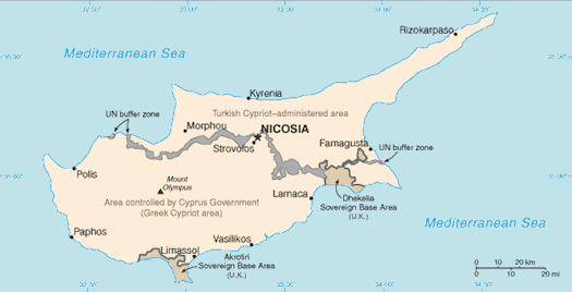
Cyprus. One island split so many different ways. There’s the de facto partitioning between Greek and Turkish Cypriots. And there’s the United Nations buffer zone created along the ceasefire line. Finally, there’s the British Sovereign Base Areas of Akrotiri and Dhekelia. This isn’t about any of those divisions. Rather the three, well actually four, tiny exclaves of the Republic of Cyprus contained within Dhekelia attracted my attention.
In fair warning, I am about to compress centuries of history and ignore points of vast geopolitical importance to focus on my very narrow interest in manmade terrestrial oddities. Students of Cypriot history will probably cringe.
British Interests
The British used Cyprus as a base to protect their colonial trade routes in the eastern Mediterranean Sea. They administering the island beginning in the latter part of the Nineteenth Century but did not exercise actual sovereignty over it. The Ottoman Empire still ruled at that time. Things changed when the Ottoman Empire sided with the Central Powers during the First World War. Now enemies, the United Kingdom annexed Cyprus and it soon became a British Crown Colony.
Cyprus gained its independence in 1960, but in return the United Kingdom claimed dominion over two Sovereign Base Areas. The island continued to remain a strategic location to the interests of Great Britain so the Base Areas were an important part of the deal establishing Cypriot independence. Britain continues to hold sovereignty over these military facilities a half-century later.
The United Kingdom classifies a Sovereign Base Area a bit differently than it considers other territories. An Administrator presides over it rather than a Governor. This is more than a difference of semantics. The Administrator reports up through the Ministry of Defence and also serves as the military commander of British forces on Cyprus.
Enclaves
That’s an interesting governance model and its probably worthy of greater attention here on Twelve Mile Circle. Maybe someday I’ll get to that. For the sake of brevity however, let’s explore the little enclaves within Dhekelia, the easternmost of the two Sovereign Base Areas instead. They appear clearly on this map from the CIA World Factbook, with two of them labeled below.
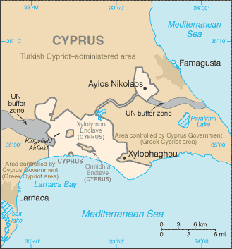
The enclaves within Dhekelia are all exclaves of the Republic of Cyprus, sovereign territory of the Greek Cypriot government. They include the fully-enveloped villages of Ormideia and Xylotymvou as well as the Dhekelia Power Station along the coast. I’ve created a map to show the approximate boundaries of these enclaves. Please bear in mind that these are not exact boundaries but about the best I could do freehand.
Ormideia and Xylotymvou
Ormideia, alternately Ormidhia or Ormidheia, take your pick of how you’d prefer to translate it from the Greek spelling, has about 4,000 residents within its confines. Xylotymvou, and again considering the same exercise, alternately Xylotymboy or Xylotymbou, has about 3,500 residents. Both areas are part of the Larnaca District of the Republic of Cyprus under Greek Cypriot control.
The Turkish invasion of Cyprus happened in 1974 and both sides respected the boundaries of the British Sovereign Base Area. Thus, Ormideia and Xylotimbou became safe havens throughout the conflict, little slices cocooned within the British lands that surrounded them. Many Greek-Cypriot refugees fleeing armed conflicts on the northern side of the island sought safety here. Some of them settled within the enclaves permanently.
The towns continue to use their unique status as a selling point. They are surrounded by rural swaths of the Sovereign Base Area that create a park-like setting untouched by the intense development found elsewhere. Crime is negligible in this confined small-town environment fully enveloped within an armed and secured military base. Neither of the towns can ever grow beyond their predefined boundaries. They share a lot in common with exclusive gated communities (reminds me of a similar situation in the United States). Yet, the villages are close to the amenities of Larnaca, the Mediterranean coast and a major airport only a few kilometres away.
Neither town is large enough to have much of a presence on the web, but here are a couple of sites with a few links, some in English and some in Greek. Both have enough photographs to provide a good sense of place.
Dhekelia Power Station
Oftentimes one will find references to the “three” enclaves, but there are four actually: a road belonging to the Sovereign Base Area cuts through the power station property from west to east. Thus the Dhekelia Power Station enclave is really two enclaves separated by the width of a single road.
The power station is located in the southern division along Larnaca Bay. Workers live in the northern division and a housing development can be seen there in the satellite image. These workers have to cross ever-so-briefly into the Sovereign Base Area to get to their jobs and then to return home over this same strange border each day.
Leave a Reply