
I don’t think of Twelve Mile Circle as a definitive source. I do my best to produce an acceptable level of accuracy. Admittedly, I’m not an authority on most geo-oddities even when I’ve been fortunate enough to visit them on the ground. It amuses me to find instances of Wikipedia citing 12MC as a footnoted reference, given my limitations. But don’t get me wrong, it’s flattering. I hope I can live up to those expectations.
I didn’t comb through Wikipedia on some kind of bizarre ego trip. Rather, I obsess over reader statistics pretty intensely, a personal quirk known well to longtime members of the Twelve Mile Circle audience. My interests stem from a geographic perspective mostly — the exotic places where 12MC visitors live and travel — and I also notice referral paths in the course of those examinations. This website receives a light and steady drip of visitors from Wikipedia, maybe one or two per day. Each one leaves a digital fingerprint on my access logs. So I satisfied my curiosity today by examining more than six years worth Wikipedia referrals captured by Google Analytics.
Shortest International Bridge

I attempted to debunk the myth of the Shortest International Bridge allegedly extending between Zavikon and Little Zavikon Islands in the St. Lawrence River. It is not. Wikipedia cites my page several times, discussing Zavikon Island, the Thousand Islands, and even a Ukranian version on that theme.
That pleased me because this erroneous tale has self-perpetuated throughout the Intertubes. Go ahead and search on shortest international bridge if you like, and see what turns up. Essentially it’s the two Wikipedia pages trying to hold steady against a torrent of misinformation.
Oddly enough, I received several days of uncharacteristic visitor traffic from Hungary a few weeks ago. Hungarians even outnumbered readers from the United Kingdom for a brief moment. I found that rather disconcerting because 12MC has a very strong and loyal following in the UK. So I traced the triggering event back to its source and discovered the reason.
Notice the photograph of the supposed shortest bridge, above. Look closely and one will see a Canadian flag on the left, a US flag on the right, and a HUNGARIAN flag in the middle. A Hungarian website featured this. The site explained that a Hungarian-born Canadian purchased the islands, and of course repeated the false claim about the shortest bridge. Then a reader left a comment poking a hole in the claim and cited 12MC. I thought that was pretty cool.
Antipodes Islands
Twelve Mile circle receives a number of regular referrals from Wikipedia’s Antipodes Islands page(s) too. From there, visitors jump to the 12MC page of the same title. Interestingly Wikipedia cited Twelve Mile Circle not for the Antipodes Islands proper. Instead it referenced the antipode of the Antipodes Islands (the portion in bold):
“The island group was originally called the ‘Penantipodes’ meaning ‘next to the antipodes’, because it lies near to the antipodes of London. Over time the name has been shortened to ‘Antipodes” leaving some to suppose its European discoverers had not realised its global location. This misapprehension persists. In fact, the island’s antipodes are situated on the territory of the French village Gatteville-le-Phare, near Cherbourg.“
My minimal added value involved a two-second effort to drop latitude/longitude coordinates into an antipodes calculator and record the resulting value. Sure, I’ll take credit even though it was rather fleeting and insignificant. Why not?
Kenedy County, Texas
It took a little more effort to notify the world of Kenedy County, Texas being both the easternmost (which Wikipedia already noted) and southernmost county in the United States with more square miles than people. 12MC first recorded that odd fact and Wikipedia cited it. I don’t think the feat required any great knowledge of the world, simply the wherewithal to create a map…
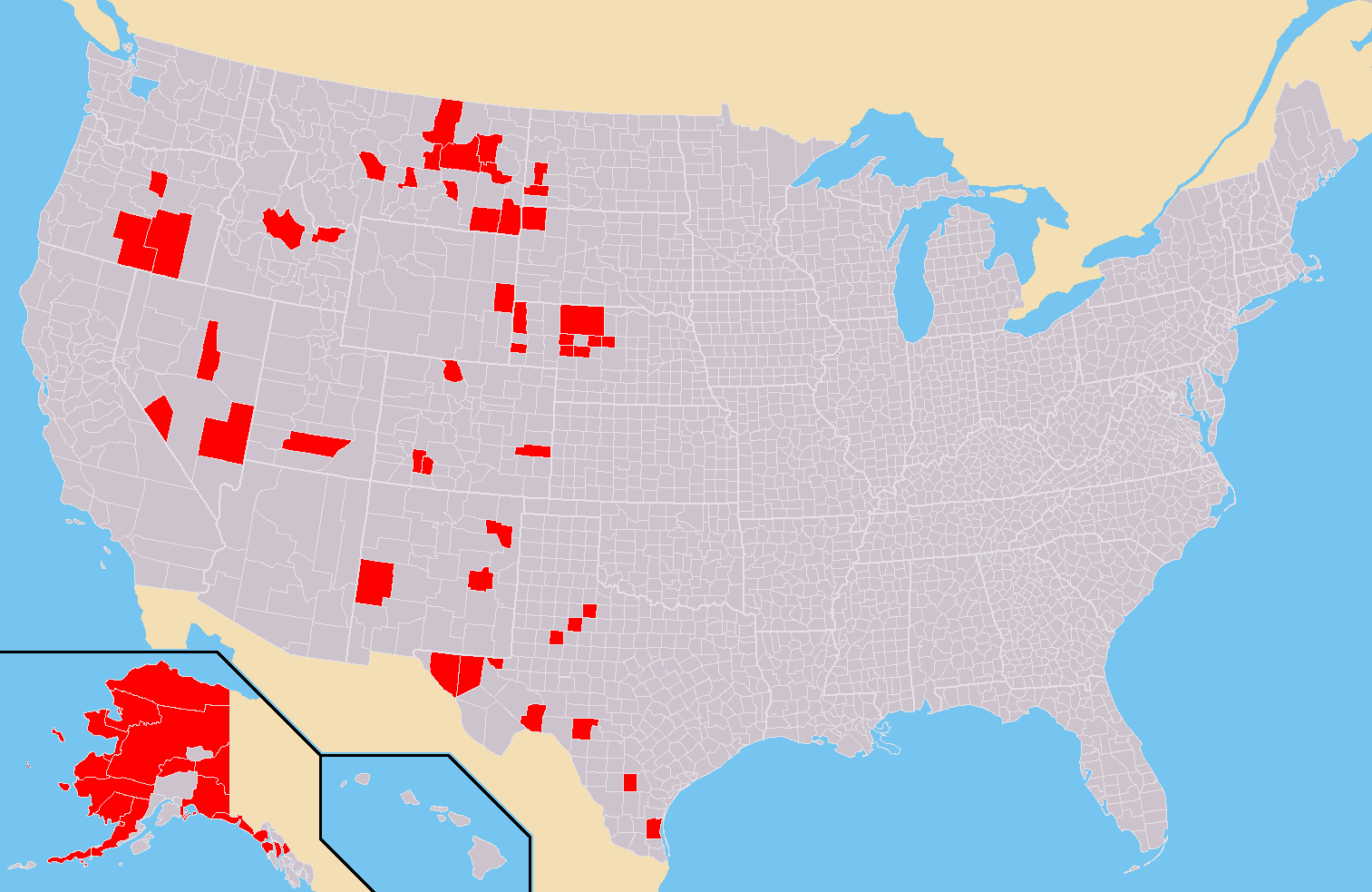
… and then proclaim, hey!, look at Kenedy County over there and down there all by itself. I challenged 12MC readers who were also Wikipedians to update their page and one of them kindly added the salient point.
Those were the primary three. 12MC also appeared as a reference on other pages generating less traffic as well as several foreign language Wikipedia pages such as German “Liste der Exklaven und Enklaven” (List of Exclaves and Enclaves); Estonian “Kiviplaatsild” (Clapper Bridges); and the “Japanese version” of Antipodes Islands. I also discovered Romanian and Hebrew Wikipedia pages. There may be others lurking out there too.
Nonetheless, 12MC references Wikipedia multiple orders of magnitude more frequently than Wikipedia references 12MC. As it should be.
Leave a Reply