
One of my favorite activities and side-benefits on Twelve Mile Circle involves thoughtful correspondence. That happens when readers contact me offline, directly through the email link. We have opportunities to share experiences, discuss geo-oddities in a little more detail and develop story lines that sometimes result in full-blown articles. Casual readers may not realize the amount of activity taking place behind the curtain. Generally I’m conducting several slow-motion conversations out-of-sight at any given moment. Over time this benefits topic variety and the overall quality of the blog.
I’m a little behind due to my recent vacation so fear not if we’ve corresponded recently. I’ll catch up eventually.
Compare and Contrast
Case in point, reader Brent and I had dueling meridian experiences in near-real-time as I traveled through Utah recently. I recorded my first visit to the Great Salt Lake Meridian and Base. On the same day he stopped at the Principal Meridian for Canada’s Dominion Land Survey.
My meridian experience was in a highly urban area, the Temple Square at the heart of Salt Lake City. His, by contrast, involved a rural stretch of the Trans-Canada Highway outside of Winnipeg, Manitoba (namesake of Winnie-the-Pooh). That rural description may change in the future, however. The outskirts of Winnipeg seem to be marching in that direction fairly steadily. The marker may find itself in the parking lot of a generic suburban shopping center someday but for now it retains its bucolic setting.
The Marker
Brent was kind enough to share photographs of the marker and with his permission I’ve reproduced one here.
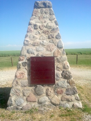
The Canadian government dedicated the marker in 1930 with the following inscription (and repeated in French):
“The first marker of the Dominion Lands Survey was placed 10 July, 1871, on the Principal Meridian, about a half a mile south of this site. The system, then inaugurated by Lieutenant-Colonel J.S. Dennis, Surveyor-General, extends across the prairies and to the Pacific coast, embracing more than 200 million acres of surveyed lands in Manitoba, Saskatchewan, Alberta, and parts of British Columbia.”
That succinctly describes the Dominion Land Survey and the importance of its Prime Meridian. It runs along 97° 27′ 28.4″ — an interestingly random longitude as I think about it. The 2nd, 3rd, 4th, and subsequent meridians were pegged to 102°, 106° 110° west of Greenwich and so forth, so it would seem to have made better sense for the Survey to begin at 98° instead. I’m sure there is a story behind the actual choice although I haven’t had time to dig into it further. Perhaps it’s as simple as they wanted to cover a greater area in the Survey.
What an amazing meridian. Canada patterned the Dominion Land Survey on the Public Land Survey system used in the United States. However it covered an even greater, more gargantuan scale. The Library and Archives of Canada described it as quite simply “the world’s largest survey grid laid down in a single integrated system.” Brent’s adventure trumps my puny Utah meridian in terms of scale and significance.
A Tiny Bit Off
If you check the actual longitude of the marker you may notice that it’s a bit off. Wikipedia explains that particular situation:
“The only truly accurate benchmarks at that time were near the prime meridian in Europe. Benchmarks in other parts of the world had to be calculated or estimated by the positions of the sun and stars. Consequently, although they were remarkably accurate for the time, today they are known to be several hundred metres in error. Before the survey was even completed it was established that for the purposes of laws based on the survey, the results of the physical survey would take precedence over the theoretically correct position of the meridians. This precludes, for example any basis for a boundary dispute between Alberta and Saskatchewan on account of surveying errors.”
That’s a smart approach.
Well done Brent, and thank you for sharing your journey.
Leave a Reply