
Evidence of earlier migrations appeared as we rolled along our Center of the Nation journey. It evoked a time when people crossed these High Plains without benefit of motors. Initially the migration involved early Nineteenth Century explorers and hunters of European descent pushing from the East Coast into lands long settled by Native Americans.
Then came their brethren at mid-century. They came in successively larger waves to avoid religious persecution or to reach the goldfields or later to homestead in fertile valleys farther west. A few of them remained in the empty plains. However, many more simply passed through on their way to Utah or California or Oregon or wherever.
I encountered small slivers of their ghostly paths in Wyoming and later in Nebraska. There weren’t a lot of options for those people brave or desperate enough to consider a transcontinental journey in the days of covered wagons. Emerging trails featured different starting and ending points. Even so, many of them converged at places towards the middle due to underlying topography, the river valleys and mountain barriers that favored certain routes.
The Mormon Trail, the California Trail, the Oregon Trail, the Pony Express, the telegraph system and the railroads all followed similar paths at points. I converged there as well for a stretch of about 75 miles (120 kilometres). Then I reflected upon some of those early pioneers’ experiences at several noteworthy landmarks.
Chimney Rock

Ironically I’d climbed a different Chimney Rock earlier in the summer in North Carolina. Arguably, the Chimney Rock in western Nebraska garnered much greater historical significance and name recognition (map). Pioneers walking the trails would have seen this landmark looming on the western horizon, a bony finger to the sky, for days before they passed it. Even today, so instantly recognizable, the state of Nebraska chose to feature Chimney Rock on its border signs and its state Quarter.
Chimney Rock rose more than 300 feet (91 metres) above the surrounding, almost level terrain. It became iconic, a famous landmark referenced ubiquitously by pioneers compiling journals of daily life along the trails. There were hundreds if not thousands of accounts.
Native Americans revered the outcrop too. But the local Sioux didn’t have chimneys. So they named the spire for something more recognizable to their hunting and gathering society, bestowing variations of the name Elk Penis upon it. That didn’t sit well with the sensibilities of new arrivals so it became Chimney Rock to those speaking English.
Regardless of name, the towering stone signified an important transition in a long journey across a vast continent. People walking the emigrant trails understood that the promontory marked the end of the plains. Soon progress would slow down, with a gradual uphill climb towards the Rocky Mountains.
Scotts Bluff

Another thirty miles (50 km) farther west following the banks of the North Platte River, emigrants encountered Scotts Bluff (map). This presented a significant obstacle. Early trails skipped the 800 foot (250 m) bluff using a southern bypass called Robidoux Pass. Mormons on their way to Utah and the gold rush 49’ers heading to California generally took the detour.
A few hearty souls took a more difficult shortcut at a lowpoint between Scott Bluff and a neighboring bluff. Things changed in 1851 when the US Army Corps of Engineers improved the shortcut and named it Mitchell Pass. It shortened the trail by eight miles (13 km). This saved at least a half day of walking, and it quickly became the preferred route.
Trail widths weren’t as precise as one might imagine. Anyone who has ever experienced a dry dirt road during the summer would understand. Oxen and wagons threw dust into the air. So Pioneers didn’t travel sequentially one-behind-the-other. Instead they fanned-out widely to avoid dust, and trail widths bore little resemblance to precisely defined modern roads.
However the tables turned at Scotts Bluff. Wagons had to pass single-file through narrow Mitchell Pass. The pounding of 350,000 people with wagons and oxen created some of the most visible signs of the Oregon Trail still in existence. Here, at Scotts Bluff National Monument, one can literally walk in the footsteps of those earlier travelers. The swale created by thousands of wagons dug several feet deep into the underlying soil. It’s clearly visible in one of the photos I took.
Fort Laramie

Continuing west along the passage of the North Platte River another fifty miles (80 km) brought emigrants to its confluence with the Laramie River. Fort Laramie (map) offered respite and protection, a spot occupied since the 1830’s when a private fur trading post opened. The US Government recognized the strategic significance of this position and acquired the post in 1849. It became the Army’s most important presence on the Northern Plains. They used it to protect wagon trains and keep a strong military force amongst Native American tribes who rightfully resented incursions upon their territory.
Fort Laramie held its key position through the entire pioneer period of the late 19th Century. It become an anachronism when transcontinental railroads replaced wagons and as Native inhabitants were forced onto reservations. The fort disbanded in 1890 and most of its assets were sold to the public. Much later the Government re-acquired what was left to create Fort Laramie National Historic Site.
Cold Spring Campground
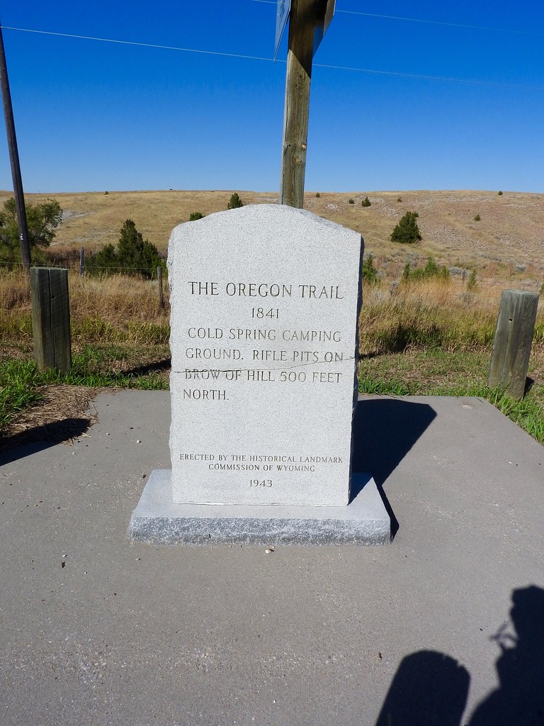
Cold Spring Campground (map) was much less significant than the other trailside sites I encountered. It was the westernmost site on my brief journey on the trail so I wanted to mention it anyway. Leaving Fort Laramie, pioneers would have arrived at the Cold Spring Campground probably after the first full day of walking. It offered a place to camp overnight with a reliable source of water. Soldiers from Fort Laramie also dug rifle pits into the nearby hillside for additional protection both for the emigrants and for their own workers who quarried stones nearby to improve the fort. There were dozens of other sites like this along full length of the trails.
I had an opportunity to cover only a very short segment of the conjoined Mormon-California-Oregon Trail path. Someday I’d like to pick one of those trails and follow it in its entirety from east to west. I will place that on the long 12MC list of activities I hope to cover when I get a chance.
Center of the Nation articles
See Also: The Complete Photo Album on Flickr
Leave a Reply