Charting the Split

I recently recorded a question of amazing specificity, what I’d call a hyper-local geographic oddity that’s probably of interest only to a handful of people. Fortunately I’m one of those very few souls and maybe you are too. I’ll tie it in with a little history to widen the audience just a bit, so stick with it for a paragraph or two and see if it grows on you. It’s still an interesting exercise. Here’s the question, rephrased for clarity:

Where would the line between Northwest and Southwest Washington be, if Arlington and Alexandria hadn’t returned to Virginia?

I love this question — the history, the geography, the hometown appeal. That’s pretty much a trifecta for me. The shill who left this question behind in my web logs deserves a percentage of the cut. His check is in the mail.


History

Original Washington DC Boundary Stone SW 8. Photo by howderfamily.com; (CC BY-NC-SA 2.0)
Southwest Stone 8

First the history. Two points are germane to understanding and appreciating the question.

  • The foundation of the District of Columbia traces back to the United States Constitution, Article 1 Section 8 as one of the Powers of Congress: “To exercise exclusive Legislation in all Cases whatsoever, over such District (not exceeding ten Miles square) as may, by Cession of particular States, and the Acceptance of Congress, become the Seat of the Government of the United States…” That’s exactly what happened. Ten miles square (i.e., ten miles on a side, not ten square miles) came from land located formerly in Maryland and Virginia. The District filled a perfect diamond shape set upon the Potomac River.
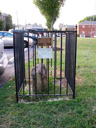
  • The portion of the District formerly belonging to Virginia returned to Virginia in 1847, an action called retrocession. I won’t go into further detail here except to skewer some local mythology and folklore once again. It had nothing to do with the Government thinking they would never need that much land. It was a two-punch combo of issues related to the economy and to slavery specifically. Even though Virginia regained the land, there are still many of the ancient, original Washington, DC boundary stones on the Virginia side of the river today.

Quadrants

Next, it’s useful to understand that the District of Columbia is split into quadrants: northeast; northwest; southeast; southwest. The dividing lines radiate from the center of the United States Capitol dome but they are not of equal sizes because the Capital wasn’t placed in the center of the city. Southwest is particularly diminutive.

USGS, modified by User:Postdlf [Public domain] via Wikimedia Commons

Let’s draw some lines and answer the question. I’ve prepared a map that shows the original pre-1847 boundaries of the District of Columbia. The North-South quadrant line isn’t exactly straight but it’s irrelevant to the question so I haven’t included it. The East-West line is indeed straight so I’ve simply extended it across the Potomac River and into Virginia.

Southwest Washington would be one of the largest quadrants rather than the absolute smallest if only the Federal government hadn’t returned the land to Virginia.

Most of you can tune out now. Those of you who know the area well — and I do know there are some regular readers that fit into that category — might actually have an interest in some of the neighborhoods that fall within either side of that fictional line.

Drill down and take a closeup of a portion of the Rosslyn-Ballston corridor. The underground portion of the Metro’s Orange Line runs right through the area and has helped revitalize it over the last couple of decades. It looks like Rosslyn and Courthouse would be in the fictional Northwest while Clarendon and Ballston would be in fictional Southwest.

Comments

10 responses to “Charting the Split”

  1. Greg Avatar
    Greg

    This is incredible: the extended line looks like it would have bisected the apartment (not building, but actual apartment) I lived in in Courthouse, near 14th and Scott.

  2. Randolph Clark Avatar
    Randolph Clark

    As best I can tell the East-West line passes through the Arlington intersection of Wilson & Cleveland.
    This is no doubt named for Jackie Wilson who is in the Rock and Roll hall of fame in Cleveland.
    http://rockhall.com/inductees/jackie-wilson/

    1. Twelve Mile Circle Avatar

      Greg: I’d claim this experience must have imparted some type mystical energy upon you, being located exactly due west of the Capitol dome and all, if only I was a believer in all that Masonic conspiracy stuff tied to the layout of the city. No, since you probably didn’t gain any superhero powers, you’ll just have to content yourself with having lived unbeknownst atop a really obscure geographic oddity. That’s more than most people can say and maybe confers some kind of special status amongst us geo-oddity aficionados.

      Randolph: I love the theory and I award you today’s high score and heartfelt kudos for a great tongue-in-cheek explanation. It would be both imaginative and well-deserved if the path led to Jackie Wilson. Why, oh why, do the facts always have to get in the way, though?!? Sadly, the more mundane explanation can be found in the Arlington County Street Naming System Guide: "…the names of 23 U.S. presidents — from George Washington through Woodrow Wilson — dignify numerous street-name signs. That is, all but Chester Alan Arthur, James K. Polk, and John Tyler. An oversight? Insufficient alphabetizing space? Or just politics?"

  3. Steve Avatar

    Interesting.

    If only because I can put this in the context of that beer we had after my conference down near Courthouse a few months ago – at which, dear readers, Tom and I spent many minutes discussing the Metro escalators and their various lengths. Good times.

    Btw, Fictional DC is discussed in Mark Stein’s “How the States Got Their Shapes,” but not to this exacting detail.

    1. Twelve Mile Circle Avatar

      Steve isn’t kidding about the Metro escalator discussion. That’s why my family calls me the "master of useless trivia." Steve, that conversation took place in what would be fictional southwest by about 1,000 feet or so in case you were curious.

  4. Greg Avatar
    Greg

    Ah, but if the streets were REALLY named after presidents, there should be two non-consecutive Cleveland streets.

  5. Greg Avatar
    Greg

    Do the extra-long escalators run faster than the shorter ones? It seems like, the longer the escalator, the longer the flat parts at each end are, so maybe that’s a way to give people enough time to get their feet situated on a faster-than-usual escalator. I’ve always meant to keep tabs on length vs. speed, and I never have.

    1. Twelve Mile Circle Avatar

      Hmm… I haven’t noticed them going any faster. It seems like forever going up the escalators at Dupont Circle and Rosslyn, which is why I usually try to walk up them.

  6. FS Avatar

    So, why IS the north-south division squiggly?

    1. Rhodent Avatar
      Rhodent

      FS: There are three “Capitol Street”s in D.C.: Capitol Street North, Capitol Street South, and Capitol Street East. (There is no Capitol Street West because the National Mall is located where it would be.) The three Capitol Streets form the boundaries between the quadrants. Capitol Street East runs in a straight line all the way to Maryland, so the boundary between NE and SE is a straight line. Since Capitol Street East is a straight line and there is no Capitol Street West, the boundary between NW and SW is simply an extension of the line formed by Capitol Street East.

      On the other hand, Capitol Street North and Capitol Street South both diverge from a straight line after a while. Those diversions are reflected in the squiggly borders.

      With that in mind, I’m inclined to dispute TMC’s claim that the division into real-world Virginia would have been a continuation of the straight line from Capitol Street East. More likely, I think, is that a street that generally runs east-west through Arlington. The roads would probably be laid out differently in this alternate history, but assuming they were the same as in the real world, I think Arlington Boulevard, 10th Street, and Washington Boulevard would be a likely path for Capitol Street East (and thus the boundary between NW and SW).

Leave a Reply

Your email address will not be published. Required fields are marked *

Latest Comments

  1. Technically it’s not always correct to say EST/CST, etc…. but just an indication that I’m changing time zone is enough,…

  2. In general, I wonder why navigating from the Atlantic Ocean to the Black Sea doesn’t count as inland navigation.

  3. Re: East/West Carroll parishes, you’re close, but the real reason for the split was more political than demographic or cultural.…