Bibb-Monroe Border War Resolved. Maybe.

Who says that Twelve Mile Circle can’t break a story? I stay away from the major geographic developments because I figure everyone else will cover them. South Sudan, anyone? You saw no mention of it that on 12MC. The smaller stories, the ones few care to follow and even fewer dare to understand? Well those are perfect fodder for this website.

I have been stalking the many twists and turns of the border dispute between Bibb and Monroe Counties in Georgia since I first became aware of it January 2009. I’ve never been to either place and I have no stake in its outcome. My interest rests solely on the possibility that a county line might change. This is an extremely rare event so I find the story fascinating. I set up a Google Alert and I received an email with article links once every few months as the dispute progressed through various government wickets. I’m nothing if not patient.


A Decision at Hand

Border of Bibb and Monroe Counties GA in January 2009

This morning, August 23, 2011, Georgia Secretary of State Brian Kemp held a press conference to announce his decision. He stated that he believed Bibb County met the necessary burden of proof to support its position. He set aside Terry Scarborough’s 2009 survey that favored Monroe County. The border will remain in its current place.

Kemp said he had reasonable doubts about the exact original location of Torrentine’s Ferry, the Nineteenth Century starting point for the boundary. It could have been where Scarborough marked it in 2009 or it could have been somewhere further upriver. Kemp reviewed all of the documentation and he personally visited the disputed area. In conclusion, he said that a change would have too big of an impact on the lives of the people affected unless he knew where to draw the line with certainty.

He stressed that the two sides could continue to work together to come up with a better solution or the Governor could always commission another boundary survey. However, Kemp decided to keep the border in place as currently configured.


Previous Developments

Readers who have not followed 12MC for the last three years are probably wondering how we got here. Let’s review.

I set up the general situation in Bibb-Monroe Border War in Georgia and updated it in Bibb-Monroe Revisited.

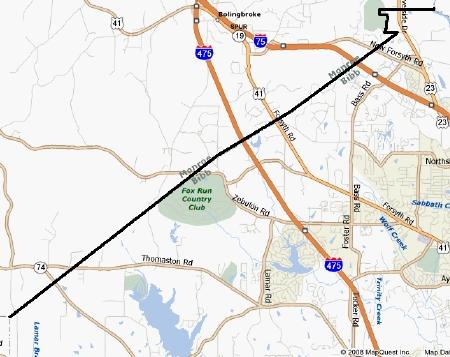
  • The border was established in 1822 with the creation of Bibb County. It was a direct line between Torrentine’s Ferry on the Ocmulgee River and the northeast corner of Crawford County.
  • Problem: Torrentine’s Ferry was out of service so long that nobody knew for sure where it actually operated.
  • Monroe County felt it was entitled to more land than recognized by the existing border so the Governor commissioned a boundary survey, which was completed by Scarborough in 2009.
  • It was more than an academic exercise. A border adjustment would allow Monroe County to collect significant tax revenue from a large Bass Pro Shop, among other benefits.
  • Granite markers were placed in a manner that favored Monroe County, causing quite a bit of excitement since it seemed to suggest a new boundary before an official decision had been made.
  • Bibb County did not agree with the results of the survey and refused to pay Scarborough for a considerable amount of his time.

It got rather ugly after that. The issue went before an Administrative Law Judge who ruled in favor of Monroe County. The Judge then presented his recommendation to Secretary of State Kemp. All the while, Kemp urged Bibb and Monroe to resolve their differences themselves. The two parties reached an impasse, forcing Kemp’s hand.

The latest round goes to Bibb County. This probably settles the issue, however Monroe County still has a couple of avenues to pursue if it wishes to continue.

I guess I’ll keep my Google Alert active.

Comments

5 responses to “Bibb-Monroe Border War Resolved. Maybe.”

  1. Bill Harris Avatar
    Bill Harris

    Georgia just seems to be a magnet for border disputes. Georgia claims that a not-insignificant chunk of Tennessee should be a part of the Peach State. The issue simmered for many years but has heated up again as Georgia has eyed water from the Tennessee River to help quench the thirst of the growing Atlanta metro area during the last drought.

    http://www.ajc.com/news/georgia-politics-elections/tennessee-border-war-resurfaces-869095.html

  2. Bill Cary Avatar

    The whole dispute would be stifled if the two counties would simply merge into one cohesive governance unit and erase the divisive border completely. Georgia has the highest number of counties east of the Mississippi River (Texas has the most, Delaware the fewest unless the technicality that Rhode Island no longer actually has counties as such)and with over a hundred counties remaining who excepting us would miss one on a map?

    I strongly feel that the future of the United States will be redrawn borders and realignments to make more economic sense in this century. Kentucky has had rumblings towards merging some of its counties into larger bodies. Georgia should get on that bandwagon too and make the warring factions give public handshakes as a sign of the future’s solidarity and potential. As middle Georgia’s population increases the suburbs will overwhelm both counties making them indistinguishable. Putting the city and the suburb into one metropolitan governance unit makes sense and would save money. The neighborhoods wouldn’t loose their charm but the duplicity in taxation and representation could be lessened by the merger.

    Then again, I do like to see rowdy, rumbling, Rebels roaring, raving, and ridiculously ranting. Yee-haw! Have at it boys! They’re trying to steal your rightful birthrights! You ain’t gonna stand for that are you?

  3. Carl Avatar
    Carl

    In Missouri we have had two rather rare instances of consolidation. Not of counties but of small towns merging. Cedar City merged with Jefferson City in the 90’s. Shortly after that what had been Cedar City was washed away in the Great Flood of 1993.

    In Southern Mo the towns of Flat River,Elvins,Rivermines,and Leadington merged and started calling themselves Park Hills. I still want to call them Flat River which was the largest town of the group. These towns began as mining camps that were closely spaced together. They eventually grew into each other and it just made sense that they merge. It was not done without a fight. Many people wanted to keep things as they were.

  4. James D Avatar
    James D

    What’s weird about the Flat River consolidation is that somehow Desloge got left out. Is that a fancier town or something?

  5. Bo Avatar
    Bo

    As in 99% of all border disputes, Secretary of State Kemp said in effect “The border has been there for 190 years. The time to adjust it passed 150 years ago. It stands.”

    He did note that the Scarborough survey was “badly flawed.” Turns out (after the fact) that Terry Scarborough is the first cousin of a Monroe County commissioner. It was also a little suspicious that Scarborough’s siting of the long-gone ferry that marked the eastern terminus of the line is in the middle of a rocky shoal impassable by anything short of a hovercraft. The existing line meets the Ocmulgee River at a sandy bottomed straight stretch that would make an ideal site for a ferry.

    Monroe is still grumbling. They REALLY want that Bass Pro distribution center.

Leave a Reply

Your email address will not be published. Required fields are marked *

Latest Comments

  1. Technically it’s not always correct to say EST/CST, etc…. but just an indication that I’m changing time zone is enough,…

  2. In general, I wonder why navigating from the Atlantic Ocean to the Black Sea doesn’t count as inland navigation.

  3. Re: East/West Carroll parishes, you’re close, but the real reason for the split was more political than demographic or cultural.…