
This week I’m on the road once again, this time in southern California. I’ve had a great time with a Google Maps Mobile feature called “My Location” released in beta last November. I realize this is probably old news to many of you. However it’s the first opportunity I’ve had to test drive it in an unfamiliar geographic setting. I can use this feature on a BlackBerry to create and center a map on my approximate location. From there I can figure out where I need to drive next. In this instance it involves finding breakfast. As the help function for this feature explains,
“If you have a GPS-enable device, this blue dot corresponds to your GPS location. At times, and if you do not have GPS on your phone, you may see the dot surrounded by a light blue circle to indicate uncertainty about your location. Why the uncertainty? The My Location service takes information broadcast from mobile towers near you to approximate your current location on the map – – it’s not GPS, but it comes pretty close.”
In Use
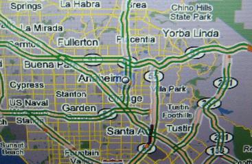
This is the resulting image from my BlackBerry. It’s not the greatest representation because I photographed it using a handheld digital camera. Nonetheless, I think it gets the point across rather effectively. I am in Anaheim, California at the moment. That’s the dot at the center. I caught it as it blinked off which is why it is white rather than blue.
Notice the light blue halo around it. That designates the uncertainty. Perhaps my Blackberry lacks a Global Positioning System (GPS) chip. Maybe it defaults to a disabled status. I don’t know. Either way, the application is keying off of nearby cell towers.
I’ve also turned on the live traffic feature which shows that most of the major roads are running smoothly (the green parallel lines). So where is that infamously bad Los Angeles traffic? Well I took photo while seriously jet lagged. It was 5:30 in the morning and I was wide awake and bored. At that time of day even LA runs pretty smoothly.
Let’s consider some of the implications
- First, if one has privacy concerns, be aware of the tremendous amount of information we leave in our wakes. Clearly someone could track my phone pretty closely if I keep it turned on and in my possession. That’s nearly all of the time. Furthermore someone could track me to within a few feet if my phone included a functioning GPS chip, an increasingly common option. I have the ability to turn this feature off for the Google Maps application but the wireless service provider would still be able to pinpoint me. Obviously we pay a privacy price for simply possessing a mobile phone, a fact we need to acknowledge.
- Second, recognize the convergence taking place in handheld devices and the manner in which Google is assessing the market. Just as they commoditized email and document software to the point where they became zero-cost to the user, they seem to be taking a similar strategy with portable GPS navigation. Manufacturers of standalone GPS navigation devices (e.g. TomTom, Garmin) and cellular providers who sell mapping services at a premium monthly recurring rate (e.g. Verizon Wireless VZ Navigator) need to pay play close attention. Disruption could come to this business model. With this beta version, Google is just one step away from combining their door-to-door mapping capability with their My Location feature into a fully functional format. For now it’s clunky and may serve in a pinch. However, once they perfect this feature it will have largely replicated the core functions of existing standalone navigation devices or cellular packages. And they will deliver it to consumers for free.
However, check with the experts
Twelve Mile Circle deals with general geography issues with a side-interest in mapping so if you wish to explore this topic further you will want to turn to the experts. Fortunately there are many technically adept people who have taken a much close look at the My Location feature and have willingly shared their insights. The best resource I found was the My BlackBerry Pearl 8130 blog, which provides well-considered real world examples illustrated with abundant screen shots. It’s worth checking out.
Leave a Reply