
Twelve Mile Circle loves mail! I’ve discovered all sorts of interesting geographic artifacts from readers who’ve sent a much appreciated note. This time a message arrived from reader “Jonathan” who has offered several suggestions in the past. So he mentioned a place he noticed while looking at maps of Australia.
He found Cameron Corner, at the intersection of New South Wales, Queensland and South Australia. This wasn’t just any ordinary tripoint, it also marked a separation between three Time Zones during periods of Daylight Saving Time – DST. I later saw that this happened at two other Australian tripoints. The concept definitely piqued my curiosity.
Cameron Corner

The specific situation that existed at Cameron Corner meant that anyone within the vicinity would have an unusual opportunity to celebrate New Years three times in a single evening. It sort-of reminded me of the instance of being able to celebrate one’s birthday twice. During DST, New South Wales followed UTC+11 (i.e., eleven hours beyond Coordinated Universal Time, abbreviated UTC for some odd reason). South Australia followed UTC+10:30 during DST. Queensland didn’t recognize DST at all so it remained at UTC+10 all year long. A post marked the actual tripoint where this rare condition occurred.
People actually lived at Cameron Corner in the middle of nowhere, albeit with a very small permanent population of two souls who operated the Cameron Corner Store. I found more information about this obscure crossroads than I would have imagined given its remoteness. Little of this came from my usual sources.
Reviews
I found another source that was great though, TripAdvisor, of all places. A fair number of people went out of their way to stop at Cameron Corner and some of them recorded their experiences in rich detail. The store included a restaurant, a small hotel, a campground, a petrol station, and a pub where it seemed like visitors made a point of drinking into the early hours of the morning. There wasn’t much else to do so far into the Outback. The site also had a 3-hole desert golf course where a round featured a hole in each state.
There were a number of TripAdvisor quotes that interested me, including a very simple description of Cameron Corner, “a metal post, a pub and a fence.” That seemed straight and to the point.
Another reviewer noted,
“There is only one shop/store on the Queensland side although their postcode is in NSW and telephone number is SA. As each state has a different time zone, they are known to have three New Year’s each year. I was told by Fenn, the shop-keeper that last year, they had about 70 guests passing this area for New Year’s and that they walked from one state to the other to celebrate the different times (which are only metres away from each other).”
“The corner itself, of course, is nothing but the marker post, the dingo fence and the Corner Store and the feeling of being remote is oh-so palpable when you arrive there and step out of your vehicle; the silence is absolute. Just magic!… This is not a trip to be undertaken lightly, though; on the trip in on the unsealed road we saw no other traffic – 280km – and only one car on the way out; spare water and fuel for the ‘just in case’ moments are a must”
Some Other Possibilities
This prompted me to look at some of the other Australian corners. Cameron Corner was the most accessible by far.

Poeppel Corner and Surveyor Generals Corner exhibited the same phenomenon, with a three state, three time zone anomaly during DST. MacCabe Corner and Haddon Corner did not, and Haddon Corner wasn’t even a tripoint. I decided to examine the first two a little more closely.
Poeppel Corner
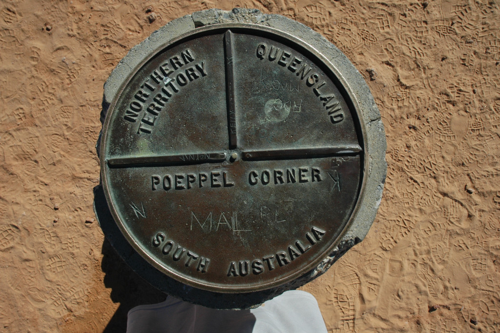
The Northern Territory, Queensland and South Australia all met at the Poeppel Corner tripoint. Unlike Cameron Corner, nobody lived there and scant information existed. The Australian National Placenames Survey included a nice newsletter article though (pdf format). The corner sat deep within the Simpson Desert, accessible only by 4-wheel drive vehicles, and registered perhaps 2,000 visitors per year:
“In 1880, Augustus Poeppel, South Australian Government Surveyor, marked the corner with a coolibah Eucalyptus microtheca post, 2.1 metres long by 0.25 metres in diameter. The post was dragged 58 miles (92 kilometres) westward from the Mulligan River. Poeppel adzed it on three sides and chiseled into it the words “South Australia, Northern Territory and Queensland”… Poeppel returned to the corner in 1883 to commence the survey of the Queensland/Northern Territory border. The post was not seen again by a European until 1936”
The nearest people today probably live in tiny Birdsville, more than a 150 kilometres (93 miles) away. Experiencing this single post in the ground requires amazing dedication.
Surveyor Generals Corner
More difficult yet would be a journey to Surveyor Generals Corner, the tripoint of the Northern Territory, South Australia and Western Australia. It contained an interesting geo-oddity though, a surveying error.
“So in 1968 two monuments were set up at the resulting right-angles where the WA border does a brief east-west zig-zag in the desert. The easternmost corner, where two states and a territory meet, was named Surveyor-Generals Corner after the three officials who attended the ceremony.”
Permissions
Two cultures crossed at Surveyor Generals Corner. People of European descent created Australian States with straight lines that formed an arbitrary tripoint. The original Aboriginal people considered the spot their own, and had occupied it for millennia. Thus, anyone who wanted to experience Surveyor Generals Corner in person required explicit permission and a guide, in addition to the usual Great Central Road permit. The Wingellina (Irrunytju) Community Office in the Shire of Ngaanyatjarraku, Western Australia could arrange that.
The Details
ExplorOz.com further discussed the logistics.
“The corner consists of two actual markers separated by a distance of 75 metres. This creates a dogleg in the WA border. It is approximately seven km north east of Irrunytju community. Both are on the land of Mr Eddy and you must be escorted to the markers by one of the traditional owners. Arrangements (permits) have to be obtained prior to heading to Irrunytju (Wingellina) thru the West Australian DIA website… Once arrived at Wingellina, head to the community centre and pay the appropriate fee (At July 07 – it was $100 per vehicle and $20 per person) and someone will be located to escort you.”
I’ve not been to Australia in awhile. However, if I’m ever lucky enough to return, I would love to push away from the coast and visit one of these tripoints. Have any of the Australian 12MC readers ever been fortunate enough to experience these places in person?
Unrelated, but not completely unrelated
In preparing this article I went back through the index and I noticed I’d posted several other Oz-centric articles over the years. Enjoy.
Leave a Reply