
Several months ago I went on a fifty mile cycling adventure on a bright, late-summer morning in Maryland. Afterwards I made an effort to describe the Bridges of Frederick County that I’d encountered. The lack of reader response didn’t deter me from my emerging fascination, either. It seems I have a thing for bridges, covered ones in particular. But I also enjoyed structures unprotected from the elements too if they embodied peculiar features.
I choose topics for Twelve Mile Circle that interest me, and perhaps not you. The audience should feel free to skip this post and wait for the series’ conclusion later this week. Or scroll through some pretty pictures of bridges. Or even keep reading if you like. I’m fine with whatever you prefer. This one’s for me.
Filling A Void
I’d been left with a quandary. My research found plenty of interesting options for the drive through West Virginia and Kentucky. However the entire premise of my road trip involved my relentless need to capture five remaining Virginia counties. I wanted to say truthfully that I’d been to every county and independent city in the Commonwealth. So naturally it was all about bragging rights.
Unfortunately I hadn’t been to most of the remaining counties for a reason; there were precious few excuses to go out of my way to see them. Coincidentally, I stumbled upon a page from the Virginia Department of Transportation and actually found it useful to my quest.
People from Virginia would understand my perplexed reaction. VDOT was responsible for road maintenance and drivers’ licenses and functions like that. When I think of VDOT, my mind shifts reflexively to endless, bureaucratic lines once every few years so I can renew my license and keep on driving. And yet, VDOT had a nice, helpful page on Covered Bridges in Virginia. My route would take me past something like half of the remaining covered bridges in the Old Dominion.
Sinking Creek Bridge

We drove from southwest to northeast so I’ll discuss the covered bridges we encountered in that same order. First came Sinking Creek Bridge, sometimes called the Clover Hollow Bridge, in Giles County (map).
It felt remote. However, it was only about ten miles (16 kilometres) from Blacksburg, home of Virginia Tech. So I imagined it must get all kinds of touristy attention on the weekends. Consider all of the University lovebirds who wanted a romantic spot for a picnic lunch in the country. Sinking Creek seemed like it would be a perfect place for that. But nobody was there when we visited and that was all that mattered to me. I could get some photographs without any actual humans in the background.
The bridge spanned about seventy feet across Sinking Creek, thus the name, constructed of modified Howe trusses. I had no idea what distinguished “modified Howe trusses” from any other trusses. Of course the intertubes helped as usual and I went on my merry way.
Vehicles hadn’t crossed the bridge for a long time, and in fact it’s lifespan was pretty short. The bridge first spanned Sinking Creek in 1916 and it was replaced by another bridge in 1949. The landowner had the foresight to consider covered bridges attractive and left it in place after its obsolescence. Thank you, random farmer person from days gone by.
Humpback Bridge
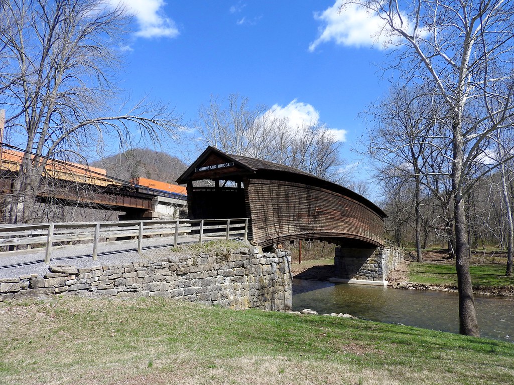
Humpback Bridge was the most well-known and visited of Virginia’s remaining covered bridges. It was easy to see why. The bridge was situated in a beautiful park-like setting along a scenic stretch of river. It also had that unusual humpback shape. Few covered bridges ever featured a hump like that, and fewer still survived.
The hump actually performed a function. Designers thought a bulge might make it less vulnerable to washing away in a flood. They actually had reason to fear that. After all, that’s what happened to several earlier bridges at the site. This one survived from 1857 so the builders got it right. Humps, apparently, were good.
Humpback Bridge spanned about a hundred feet as it crossed Dunlap Creek, a tributary of the Cowpasture River that flowed to the James and onward into Chesapeake Bay. It fell into disrepair after a steel truss bridge replaced it in 1929. Several sites stated that a local farmer even used it as a makeshift hay barn. Then preservationists noted its quaintness and pushed for preservation.
While located in rural Alleghany County, Humpback Bridge was just outside of the independent city of Covington and an easy 5-minute detour from Interstate 64 (map). There were even tourists there during our mid-week off-season stop. I imagined it might get pretty busy on summer weekends.
Meems Bottom Bridge

The bridge at Meems Bottom was considerably farther north than the other two, way up on Interstate 81 in Shenandoah County. It was actually only a couple of miles from Shenandoah Caverns (which we also visited). So anyone traveling to see the cave could easily combine it with a visit to the bridge as we did. I’d recommend it.
The bridge offered something the others did not; it was still operational. Wissler Road ran directly across its deck. That was a fun experience, driving an automobile through a wooden tunnel over the North Fork of the Shenandoah River (map). Meems Bottom Bridge spanned about two hundred feet so it was considerably longer than the other two we’d visited the previous day, too.
This wasn’t the original Meems Bottom Bridge. Vandals burned the circa 1894 structure sometime in the 1970’s. Local officials salvaged what they could and rebuilt the bridge to its original specifications. I think they did a fine job. It looked attractive and my car didn’t fall through the floorboards and into the river. I’d say it performed its stated function flawlessly.
Nolan Toll Bridge

I had a story from earlier in the trip along the Tug Fork, on the border of West Virginia and Kentucky. It involved a rather unattractive concrete bridge instead of a covered bridge. Even so, it was still a bridge so I felt I could shoehorn it into the article. I noticed that our path would take us very close to Martin County, Kentucky and I could capture it with just a tiny jog along our route. That seemed entirely feasible. The Nolan Toll Bridge (map) crossed the Tug Fork at Nolan, West Virginia and from there Martin was maybe a half-mile away.
However, in Satellite Mode, the bridge looked sketchy. I’m glad my intuition led me to examine the situation closer. Some quick research uncovered a March 2015 article in the Mingo Messenger, “Searching for answers at Nolan.”
The bridge had been built as a private toll bridge in 1963 and fell into disrepair after the owner retired and moved from the area. However, neither West Virginia nor Kentucky wanted to own it because it needed renovation. It remained open, an “at your own risk” situation neither prohibited nor sanctioned. So people continued to drive across the bridge because it offered a convenient shortcut.
Then in 2012, someone had to come along and ruin the whole arrangement. The driver of a tractor-trailer decided to cross the bridge — and based on my quick in-person examination I’d say that he demonstrated extremely poor judgment — and got stuck on the railroad crossing at the far end of the bridge. No surprise, a train struck the truck. Nobody was hurt although that was enough for authorities to shut the bridge down. I noticed that someone had taken a backhoe and carved a chasm through the asphalt leading up to the bridge on the West Virginia side. They were serious about it. None shall pass.
Fortunately I figured this all out before I arrived because Google thought the bridge was still passable more than three years after it closed. Of course I had to stop and take photos before detouring to the longer route down at the next bridge and doubling-back, to capture Martin County. I actually considered jogging across and capturing Martin on foot (to make it a true “footloose” visit) and decided it was unsafe — not the bridge, rather the road on the other side. It lacked a shoulder and I didn’t want to become roadkill.
Others

There was a nice display about the New River Gorge Bridge at the West Virginia State Museum in Charleston. I liked my in-person visit better, though. Oh, and I supposed I could also count the little bridge near where Asa Harmon McCoy died. Indeed, there were plenty of bridges along this journey.
Appalachian Loop Articles
See Also: The Complete Photo Album on Flickr
Leave a Reply