
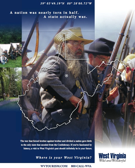
It’s not everyday that an advertisement comes complete with a mysterious Latitude/Longitude coordinate. My local newspaper included a special section on the upcoming 150th anniversary of the Civil War in the United States. This image from West Virginia filled the entire back page.
The copy reads,
“A nation was nearly torn in half. A state actually was. The war that forced brother against brother and divided a nation gave birth to the only state that seceded from the Confederacy…”
It also includes a very precise location, 39°05’49.19″N, 80°28’00.72″W.
The advertisement does not disclose what one will find at that location. Presumably it relates to Civil War in some manner or another. I dropped the coordinates into Google. Unfortunately it returned only a single English language page, a Guide to Historic Sites in West Virginia. Undoubtedly that will change the moment I post this article and Google indexes it. For now it’s the only one.
Jackson’s Mill
An analysis of the map shows that it corresponds to a place called Jackson’s Mill. The West Virginia University Extension Service operates this facility. Here’s how they describe it:
“WVU Jackson’s Mill, home to West Virginia 4-H camping, is a rustic-style conference and gala facility in a historic heritage-based setting a few miles outside of Weston, W.Va. Jackson’s Mill is also home to the West Virginia Fire Academy, a one-of-a-kind training facility for volunteer and professional firefighters from around the state and nation.”
The Guide to Historic Sites provides what is likely the smoking gun. “Confederate Gen. Thomas ‘Stonewall’ Jackson grew up in a log cabin farmstead on this site.”
I think most of the U.S. audience is probably familiar with Stonewall Jackson. However, please feel free to check his extensive biography if you don’t know his story. I suppose the advertisement featured this location as a means to demonstrate the contradictions that often occurred during the war. Jackson became a famous Confederate general. Meanwhile, his grew up in a homestead that remained within the Union.
The underlying theme of the advertising campaign is “Where is your West Virginia.” Maybe the photos in the advertisement came from the recent Jackson’s Mill Jubilee that included an encampment of Civil War Reenactors? Could the solution be that simple?
If so, My West Virginia would be somewhere around 38.053977,-81.068269 on some classic whitewater along the New River.
More Thoughts
I dunno. I’m thinking there must be more to this riddle. If I were a geocacher I’d be racing to that exact spot to be the first to arrive there and see what’s been left behind. It’s too precise a coordinate to simply mark the corner of a field on a homestead where Stonewall Jackson lived as a child.
It’s not lost on me, by the way, that I’m being used as part of a guerrilla marketing campaign. Obviously they threw the lat/long out there hoping a geography or history buff would latch onto it and blog about it, and generate some free publicity for them. Well I’m both, and I’m also a bit compulsive so I can’t help myself. I can see the the fine folks behind the campaign talking amongst themselves over coffee this morning, “well it’s about time someone noticed our breadcrumb.”
I hope West Virginia Tourism at least throws a little link love my way in return. Or lets me in on the secret.
Goodness knows I’ve driven longer distances for stranger reasons.
Leave a Reply