A Town’s Odd Streets and Enclaves

Geo-oddities exist everywhere. You just have to look for them. I came across an interesting situation in Bothell, Washington, fascinating in its own right but leading to a confluence of events even more unusual.

City of Bothell. Photo by Peter Stevens; (CC BY 2.0)

So the situation begins with the city’s placement directly atop a boundary line separating King County from Snohomish County. That’s hardly unique. County lines bisect towns all over the place.

Most streets here are named rather unimaginatively, too. Numbered avenues run north-south and numbered streets run east west. As an example, City Hall sits at the northwest corner of 101st Ave., NE and NE 183rd St. So everything here appears boring but conventional. However, let’s consider the situation a little more closely. Examine Bothell’s street names at the county line and something strange takes place.

An Interesting Jump

Notice the addresses. Now click the image forward a single frame. The street name change abruptly, jumping from 100th Ave NE to 19th Ave SE. It happens right where one section has been repaved more recently than the other, forming a mark across the road. That’s the county line. The two counties, King and Snohomish, use vastly different baselines that do not mesh with each other. Bothell, a single town, has completely schizophrenic streets. They change numbers drastically passing from one county to the other, often in mid-block.

Open the image in another tab and switch to map option to see the disjointed naming changes that take place along the county line. Imagine trying to navigate through that mess.

I wanted to see the true extent of the situation but the major online mapping services do not generally provide town boundaries. Instead I went onto the City of Bothell website and found their municipal map. This was a great resource that helped me track the name changes occurring along the line.


Holes Too!

Then I noticed something even more unusual. Bothell hosts four small independent enclaves enclosed entirely within the town’s boundaries.

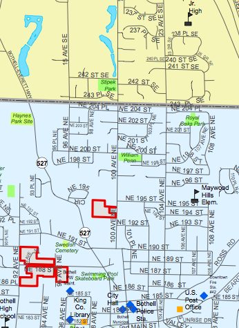
This is a detail of the Bothell map showing the four enclaves. Notice the yellow and blue parts of the map too. Those are the portions of Bothell on different sides of the county line, where street names change.

So I wondered how those four small spots could have remained a part of unincorporated King County completely surrounded by a town of thirty thousand people. I also figured I’d never get the real answer.

However, sometimes I get lucky like I did today when the answer fell right in my lap. It turns out that Bothell is in the middle of an effort to annex additional territory including the embedded enclaves. An article appeared in the Bothell Reporter [article no longer available on the internet] just a week ago, providing this smoking gun:

“… Incidentally, how exactly did those small swathes, or islands, of unincorporated King County get set aside as Bothell expanded? Wiselogle said as the city grew in the 1930s and 1940s, officials apparently encountered small pockets of opposition here and there. For whatever reason, Bothell made the decision to leave those opposition areas alone and they remain outside the city today.”

Why don’t these people want to live in Bothell?

Actually, that’s not a fair statement. I should probably ask why residents of this enclave didn’t want to live in Bothell back in the 1930s and 1940s. Either way, they’ll soon be joining their neighbors in a common jurisdiction if the annexation succeeds.


Posted

in

, , ,

by

Comments

4 responses to “A Town’s Odd Streets and Enclaves”

  1. Joshua Avatar
    Joshua

    Ah yes, I had fun updating and redrawing in town boundaries on maps as a map editor. Then making sure the production department accurately draws in them was even more fun. That was the most difficult part for both sides.

  2. Pfly Avatar
    Pfly

    Heh, I live in Edmonds, a bit west of Bothell. The county line is about a block from my house, and the nearest arterial road is right on the county line. It is both 205th St and 244th St. The nearest north-south arterial is 104th Ave NW, AKA 12th Ave W. It is all most annoying! It certainly makes giving directions harder than it should be.

    Edmonds also has an unincorporated county enclave (Snohomish County in this case), called Esperance. As with Bothell, Edmonds has been trying to annex Esperance for years. I don’t know the full story about it, but odd bits and pieces of unincorporated areas, and city annexations, seems fairly common around here. It’s always seemed weird to me–having grown up in western New York, where counties are divided fully into mostly square towns/townships, whose borders haven’t changed since they were created nearly 200 years ago.

  3. BigFoxy Avatar
    BigFoxy

    Fort Wayne, IN has a similar issue with streets changing names. There the townships named the streets and as the city grew they kept the old street names, very difficult to give someone directions. Also, they have the interstion of St. Joe Road, St. Joe Center Road, and Upper St. Joe Road. Very confusing for outsiders.

  4. Benjamin Lukoff Avatar

    Glad to see a Seattle suburb make your blog — especially in a post dealing with enclaves, annexations, and, best of all, street names. (This is a pet subject of mine — see http://crosscut.com/2010/03/22/seattle/19681/ and http://crosscut.com/2009/10/27/neighborhoods-communities/19316/ .)

    Most of King County uses the Seattle baselines. I believe downtown Renton is an exception, as well as downtown Kirkland. There may be some others. But for the most part, the Seattle grid extends throughout the county, which results in street numbers going into the 400s if you go far enough east. I am not sure why this happened — if you drive around Kenmore or the rest of Kirkland, you’ll see historical street signs showing that these communities once had their own street names. (As did, frankly, most plats back in the day. Seattle’s system wasn’t always uniform.)

    If this were long enough ago, I’d think Bothell might opt to adopt its own system, but my guess is the town was originally incorporated in King County and never considered it might be split by a jurisdictional division that corresponded to wacky changes in nomenclature.

    I wonder how many people in Bothell realize that their NE streets are numbered north from Seattle’s Denny Way, and their avenues NE numbered east from Lake Union?

    Thanks again for this post.

Leave a Reply

Your email address will not be published. Required fields are marked *

Latest Comments

  1. In general, I wonder why navigating from the Atlantic Ocean to the Black Sea doesn’t count as inland navigation.

  2. Re: East/West Carroll parishes, you’re close, but the real reason for the split was more political than demographic or cultural.…

  3. Clint, 24 March 2021. I’m 89 years old and have traveled the 100th Meridian for years between Uvalde, TX and…