
The Atlas of Historical County Boundaries is an ongoing project undertaken by the Newberry Library in Chicago. When fully completed, the effort will result in the presentation of all United States county boundary changes. These stretch from their creation during colonial times all the way through the 21st Century. The Newberry Library explains why it decided to focus on counties:
“…the judicial system is administered by counties. Counties administer most state laws and, in the process, they collect large quantities of important information, such as records of births, marriages, deaths, probated wills, real-estate transfers, and voting. Counties have been the principal geographic units for the collection and aggregation of data from colonial/territorial, state, and federal censuses, especially counts of population. Outside densely populated cities, counties have served as the building blocks for congressional districts and for colonial, territorial, and state legislative districts.”
This involves a highly complicated and laborious effort and it has been underway for several years. The library publishes its results in multiple forms:
- On paper in a book;
- In shapefiles for use with GIS programs;
- As an interactive map available on their website.
They’ve completed numerous states and others are in various stages of production.
A Practical Example
These maps are of great value to professional historians and researchers. Even amateurs will enjoy them, for example to assist with local history or genealogy.
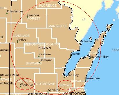
As an example, suppose genealogists knew that their ancestors lived in Wisconsin when it became a state in 1848. They would probably turn to the 1850 United States Census to track them down. This was the first national census to provide names and other identifying information for every member of the household rather than just the head of the family.
Say those early pioneers moved even further north into the state around 1849 and were among the first settlers near what would become the town of Waupaca. Today that’s the seat of government for a county with the same name. But Waupaca County didn’t exist until 1851. In that case, where should a researcher look for those valuable 1850 census records?
The Atlas of Historical County Boundaries would quickly narrow the research to census records for Brown County. However, that wouldn’t be obvious without the Atlas. Modern maps clearly show that Brown County isn’t even contiguous with Waupaca County today.
Researchers require a crosswalk that delineates boundary changes over time, and here the Atlas becomes a particularly useful tool. It provides a number of layers such as current county boundaries and seats of government that users apply to a base map of earlier periods. This ferrets out the answer. In the example map above the answer appears in the red circles I added.
Leave a Reply