
The vast empty spaces of the Southwest offered great scenery with long distances between stops. That didn’t bother me. I liked driving and I enjoyed the view. We found plenty to do along the way too, mostly outdoors. Every place worth a detour also included a signature hike of some sort. Even the most crowded parks seemed quiet when we took trails bypassed by the more sedentary tourists. Unfortunately my lungs, long acclimated to life barely above sea-level, struggled with altitudes that sometimes topped ten thousand feet. I felt short of breath at times although I bounced back like a pro by the end of the trip.
Agua Fria Peak
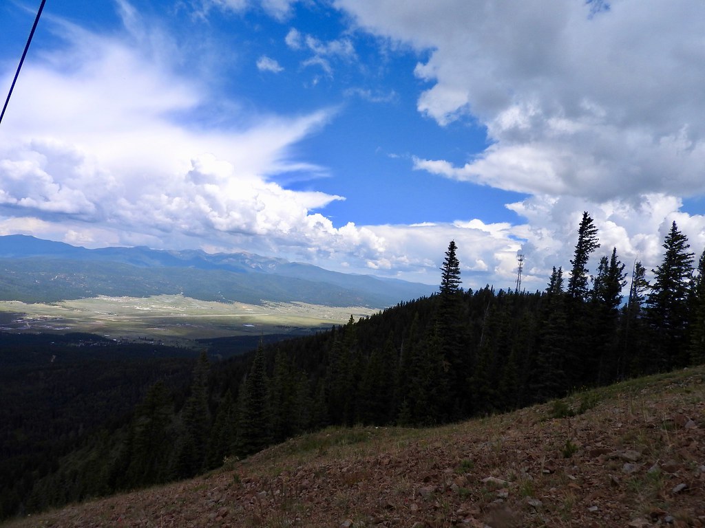
The first hike might have been the most strenuous even though it took us directionally downhill. We began the morning by riding the chairlift up Agua Fria Peak (map) at the Angel Fire Resort in northern New Mexico. From there, we hiked all the way down the mountain, a distance of four miles plus change (6.5 kilometres). We were warned to stay on the trail and avoid ski runs because mountain bikers used them during the summer. I didn’t really want to get clipped by a bicycle under momentum so I followed that advice.
The trail began at an elevation of 10,600 feet (3,230 metres) and descended all the way to the valley floor. That was high enough to make me feel a little woozy although at least we were heading downhill. Forests of pine and aspen provided plenty of shade, and a bit of protection when the brief daily summer “monsoon” rumbled across the hills. Highlights included amazing mountaintop views, the aerial acrobatics of mountain bikers on adjacent trails and a wildlife encounter with a grouse of some type.
Tsankawi Ruins Trail

Most people going to Bandelier National Monument only see the main unit. We did that too although we also stopped at the lesser-known Tsankawi unit a few miles further north. Tsankawi could only be approached on foot using a 1.5 mile loop trail. Paleo-Indians lived in a village on the top of the mesa there, maybe until the fifteenth century (map). They chose their location wisely. They could spot adversaries from long distances and defend the high ground.
Volcanic ash blanketed this entire area millions of years ago leaving a soft layer that became a rock called Tuff. As my son liked to say, tuff wasn’t tough. People stepped upon the tuff for hundreds of years and carved paths into the stone with their feet. Little walkways climbed over and covered the mesa, the same walkways used by modern visitors today. It felt soft and strange; not quite rocky although not quite spongy either. My hiking boots picked up a distinct gray dusty tinge from the climb.
Pre-Columbian inhabitants of Tsankawi also carved into the tuff itself. They created myriad places to stash their wares in addition to the pueblo they built atop the mesa. We barely saw another person as we hiked the loop and examined evidence of this vanished settlement.
Pueblo Alto Trail
Our most remote hike took place at Chaco Culture National Historical Park. Its secluded location pretty much defined “middle of nowhere.” I guess the several miles of dirt and gravel road leading into the park scare away most people. In a sense that seemed unfortunate because a lot of folks missed out on something pretty amazing. Nonetheless, it offered us a full day away from crowds, and even more so once we hit the trail.
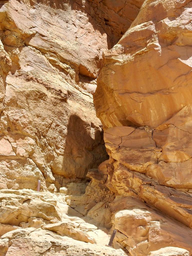
I first traveled to Chaco twenty five years ago and I remembered being impressed by the hike atop the mesa above its signature ruins. My return trip showed that I needed to follow the Pueblo Alto Trail to get there. Unlike that earlier trip, we didn’t have enough time to hike the entire trail so we turned around at the Pueblo Bonito overlook (map), a two mile out-and-back. Officially this was considered a “backcountry” hike that required registration at the trailhead.
Two miles sounded easy enough in theory although I’d forgotten how the trail made it up to the top of the mesa. The photograph above looks like a sheer cliff. But a fissure cut vertically through the middle. Hikers had to reach the base of the fissure on a steep path, then wriggle uphill through a narrow passageway until reaching daylight. The original inhabitants used this same path for several hundred years. We weren’t used to such acrobatics and it seemed a little scary. There weren’t any safety devices, just climbers versus rock. The whole family managed to make it to the top without incident and we followed the trail along the cliff to view some great ruins from an elevated perspective.
Petroglyph Point Trail

Chaco Canyon and Mesa Verde National Park seem like opposite bookends. Few people visit Chaco and hordes visit Mesa Verde. I’m sure the nice paved road to Mesa Verde made all the difference. Even tour buses could drive easily into the depths of the park. We arrived too late in the day to get tickets to any of the major sites, though. We had to satisfy ourselves with glimpses from a distance at viewing platforms on the opposite cliff. Even so, our mobility and willingness to get away from the beaten path took us to places far away from the crowds. This revealed some remarkable archaeological sites.
We selected the Spruce Tree House trail. This one led beneath the mesa rim, into some of the protected shelves where the original inhabitants built their homes. It terminated at Petroglyph Point (map), and the largest array of petroglyphs anywhere in the park. Only hikers willing to move beyond normal park amenities could ever see them. From there, the trail climbed up the mesa and continued along the tabletop to complete the loop. The whole affair lasted about 2.4 miles, some of it rather strenuous.
It felt great to get outdoors. The kids didn’t even complain. Much.
Articles in the Four Corners Series:
See Also: The Complete Photo Album on Flickr
Leave a Reply